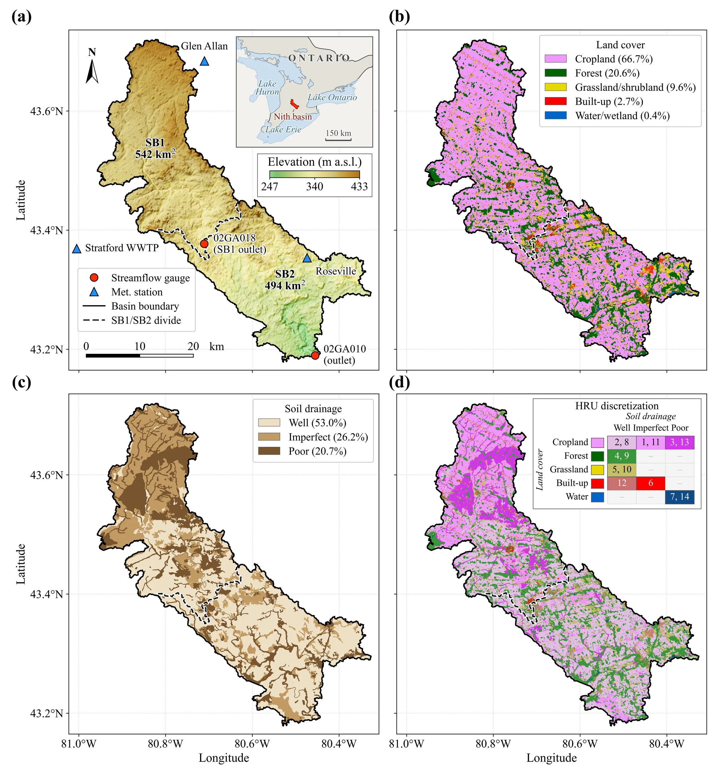
The Nith River basin (same as the previous assignments) is located upstream of HYDAT gauge 02GA010 in southern Ontario. The interior gauge (02GA018; New Hamburg) divides it in half, and both gauges have long-term coverage of in-situ flow, and meteorological forcing data (three ECCC climate stations) are available for 1986-2005, suitable for climate-oriented analysis. Also, roughly one sixth of the precipitation falls as snow; therefore, examining the snowmelt regime under future scenarios is particularly important for the region.
How would the Nith River basin behave under future (CMIP6) climate scenarios? Specifically, how would the timing and volume of the spring freshet, peak flow, low flow, and snow regime dynamics differ from what they are now?
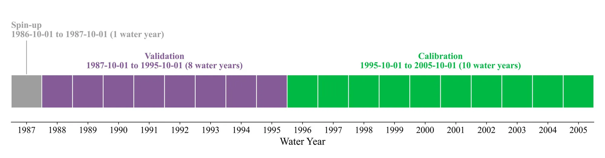
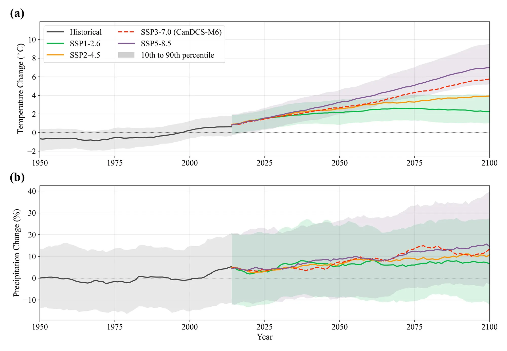
Developed an HBV-EC Raven model (Craig et al., 2020) for a basin with 14 HRUs (based on 5 LULC and 3 soil classes), with precipitation split between snowfall and rainfall based on temperature; infiltration/runoff determined by RAINSNOW_HBV and HBV_BETA; and slow and fast reservoir differentiation. Calibrated it manually first to assess the sensitivity and plausibility of the parameter ranges, then fine-tuned it with DDS (Tolson & Shoemaker, 2007), and further with Fletcher-Reeves (Fletcher & Reeves, 1964). Then answered the question with the delta-change method by perturbing the observed forcing using monthly change factors (Anandhi et al., 2011) from 102 downscaled CMIP6 model-scenario combinations (26 global climate models, 4 shared socioeconomic pathways), re-running through the calibrated model as a 204-member ensemble (102×2 horizons; 2041-2070 mid-century and 2071-2100 end-century).
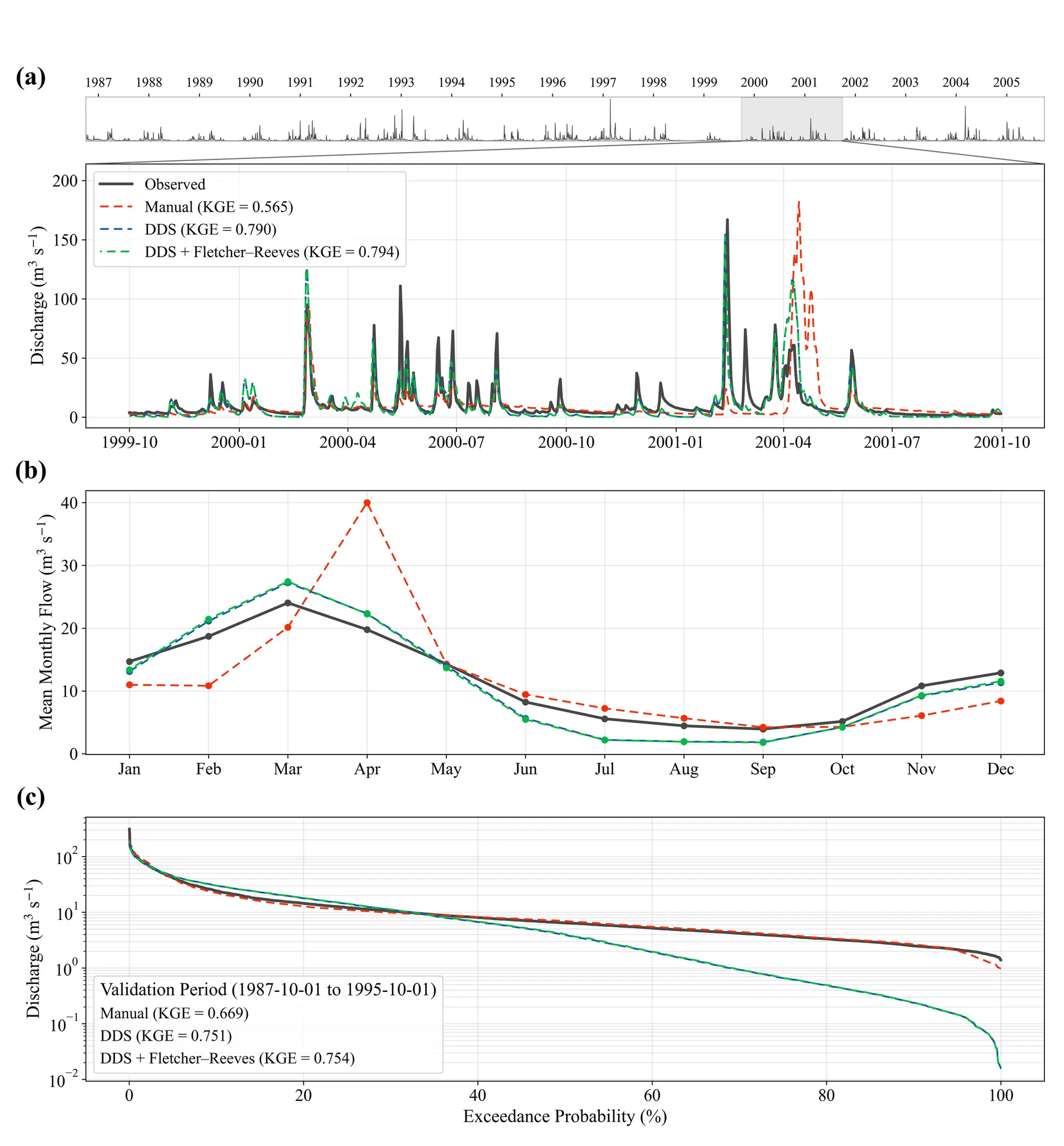
The main outlet yielded an NSE of 0.594 (0.558) and a KGE of 0.794 (0.754) in calibration (and validation in parentheses). The one metric that clearly fails is the log-NSE of -1.06 at the outlet in calibration.
| Gauge | Period | NSE | KGE | log-NSE | PBIAS (%) | RMSE (m³ s⁻¹) |
|---|---|---|---|---|---|---|
| 02GA010 (outlet) | Calibration | 0.594 | 0.794 | -1.063 | -5.7 | 11.25 |
| 02GA010 (outlet) | Validation | 0.558 | 0.754 | -0.642 | -5.79 | 11.66 |
| 02GA018 (interior) | Calibration | 0.609 | 0.768 | 0.501 | 6.23 | 7.9 |
| 02GA018 (interior) | Validation | 0.628 | 0.717 | 0.459 | 6.18 | 7.74 |
 (opens in a new tab)
 (opens in a new tab)
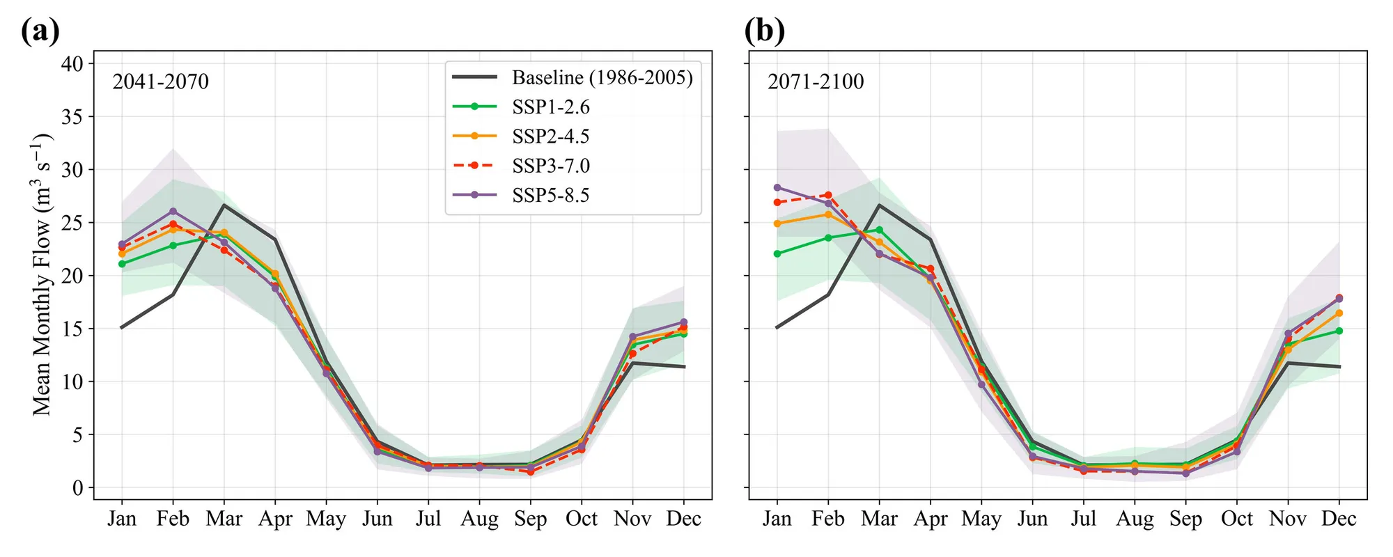
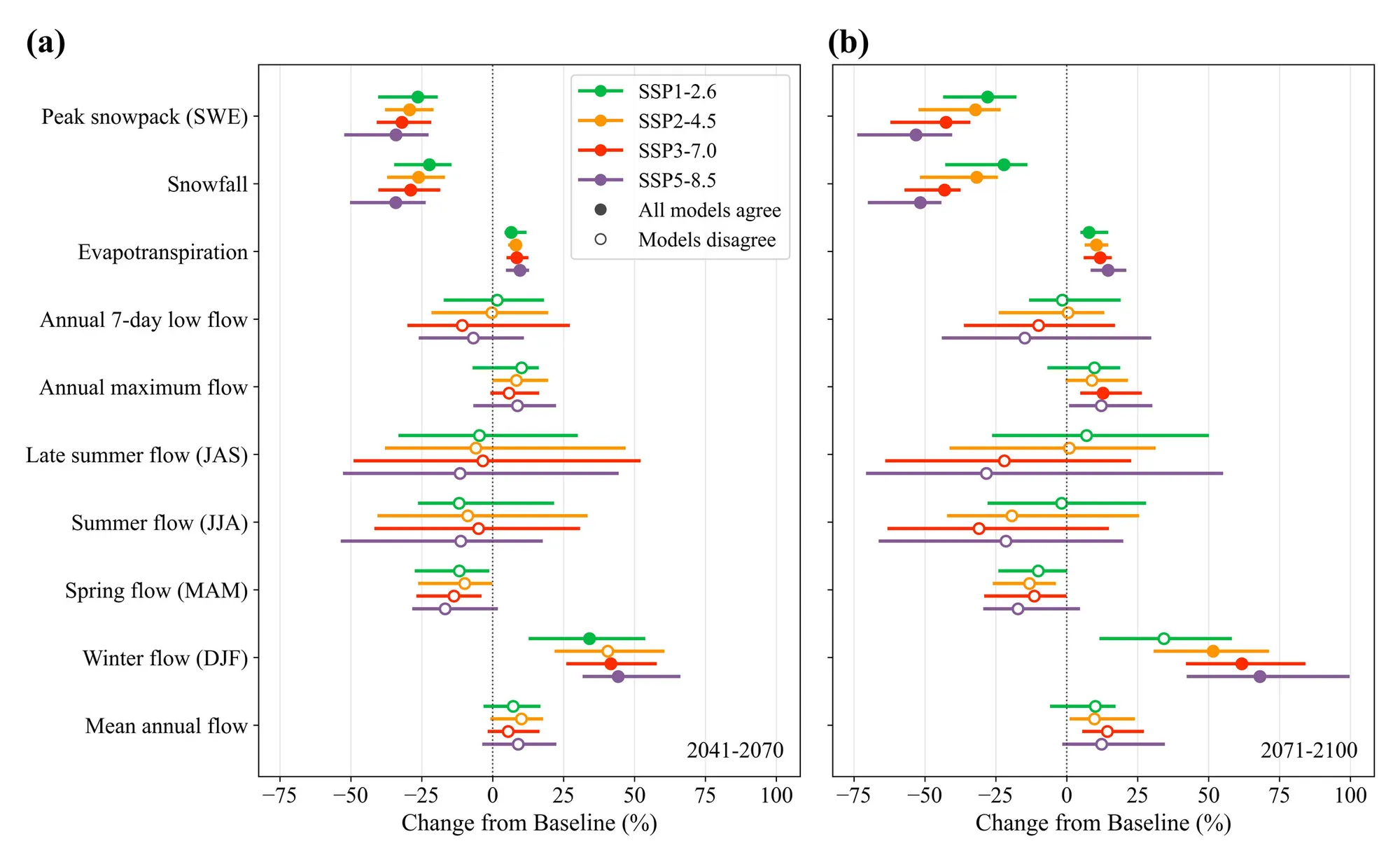
Winter (DJF) flows in all four scenarios and both future horizons are higher than the baseline, while spring flows, again in both horizons and under all scenarios, are lower. Summer (JJA) and early-autumn (Sep-Oct) mean flows, on the other hand, show no robust difference from the baseline and remain at or below roughly 5 cms at the outlet. Probably the key takeaway from this part of the analysis is that the peak-flow month shifts from the historical March to February (and toward January under the strongest late-century forcings).
Overall, it is fair to say that the snow regime within the basin is set to change markedly, and the freshet is migrating to earlier days (with more water): the basin will likely transition from a snowmelt-shaped to a rain-dominated winter regime, while total volume and extremes remain genuinely uncertain.
 (opens in a new tab)
 (opens in a new tab)
 (opens in a new tab)